


Last week we embarked on a journey around Tasmania, the beautiful island state south of the Australian mainland. We took a trip out to Freycinet National Park to the east, so this week we’ll head north and explore the most remote sections on the northeast side.
I began my day with an email from my friend Andrew back in Seattle. The U.S. CGC Polar Star, the ship I was to meet in about a week, was probably not going to be able to dock in Hobart, due to a conflict with a huge cruise ship. They would probably have to dock in Melbourne or Adelaide – disappointing, but not completely unexpected. Oh well, nothing I can do about it – time to hit the road.
The entire eastern side of the island is one beautiful beach after another, but as you head north, the roads get worse and the crowds get thinner – much worse, and much thinner, in fact.
Heading north from my campsite in Freycinet National Park, I first stopped off at Friendly Beaches. The area is known for its fishing and surfing, but I just came to look. I just can’t get enough of that gorgeous turquoise water washing up on those pristine white sand beaches.
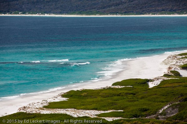
The surf washes up onto Friendly Beaches, in Tasmania, Australia.
Near here I met a nice young couple from Belgium. I asked them about their plans, and they told me that they were employees at a hotel in the town of Derwent Bridge, and were taking a few days off to explore. Once they had enough cash from their jobs, they would move on around the globe. I said, “You’re doing a reverse walkabout!”. It seems I’ve run into Aussies all over the world doing the exact same thing, which they call “walkabout” (a concept borrowed from the Australian aborigines), but I’d never run into someone from outside Australia doing that inside Australia. This may have something to do with the fact that I’d never been to Australia before.
Anyway, they asked me about my plans, so I told them about always wanting to visit and photograph Tasmania, and timing it to meet with my friend Kara on a US Coast Guard icebreaker that was likely not coming. Then I asked them about the best places to visit in Derwent Bridge, since it was further ahead on my route, and we parted ways.
Further north, I found a marina in St. Helens that had coin operated showers, and then stocked up on more groceries for my remote excursions to the far north east of the island. I wanted to get a view of the Bay of Fires beaches, so named because of all the aboriginal fires along the coast when Captain Tobias Furneaux sailed by in 1773. The coastline here, as on the rest of the east coast, is known for white beaches, blue water, and orange-hued granite caused by the lichen that covers them.
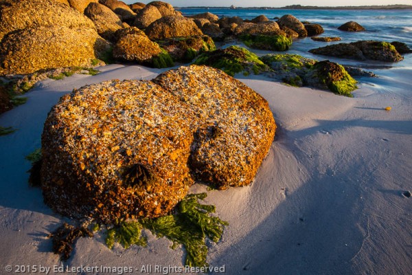
Rocks covered in lichen and seaweed line the edge of the beach beside Purdon Bay, in Mount William National Park, Tasmania, Australia.
Roads in this area are scarce, so I had to settle for a couple of peek-a-boo views of the Bay of Fires from the south end at The Gardens and the north end at Ansons Bay. I couldn’t see much that I hadn’t already seen elsewhere from these vantage points, so I started heading for my planned campsite, a place called Deep Creek in Mount William National Park, near Eddystone Point. There was a lighthouse at the point, too, so I should have plenty to photograph at sunset.
Roads in this area are listed on the map as Minor unsealed, which means not good. They are covered in the sharpest, roughest gravel you can imagine, and the entire time you wonder if your tires are going to make it.
I finally got to my new campsite, pitched the tent, and headed to the beach. I found more rocks with orange lichen, and I found some little shorebirds called Sooty Oystercatchers, black birds with the brightest orange feet, beaks, and eyes you’ve ever seen!
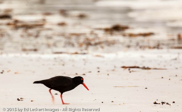
A Sooty Oystercatcher forages for supper on the beach near the Bay of Fires, in Mount William National Park, Tasmania, Australia.
After playing on the beach I got back in the car and rushed over to the lighthouse before it got too dark. Agreement for the need of this striking pink granite tower occurred in 1875 due to the numerous shipwrecks off the coast, but it wasn’t completed until many wrecks later in 1889.
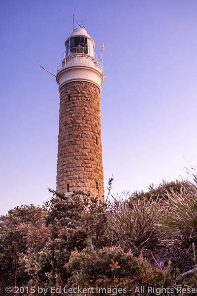
The Eddystone Point Lighthouse, built in 1889, stands guard at twilight, in Mount William National Park, Tasmania, Australia.
Sure enough, when I crawled out of my tent the next morning, one (thankfully only one!) of my tires was completely flat. I decided that this was a good time to check for an inflated spare in the trunk of my rental car, and fortunately one was there. So, I broke camp and drove very carefully on the most direct route back to civilization, over more Minor unsealed roads, of course.
Come back for more adventures next week!


![]()