


As Seattle settles in for another three months of winter and much of the rest of the nation braces for Winter Storm Walda and its associated blizzard conditions (I do not make this stuff up), I’d like to take you to a warmer place and time and focus on something really warm – the sun!
Early last year I noticed that the U.S. was due for an annular solar eclipse in May. An annular solar eclipse is essentially a total eclipse that didn’t work out – the moon is too far out to completely cover the sun. But hey, I’ve never been in the center line of a solar eclipse, annular or otherwise, so I knew I had to be there for this one.
Well, step one in preparing for any solar eclipse is figuring out where the darned thing is going to be visible. I found lots of maps that described the path and important viewing details of this particular eclipse, but the one that interested me the most was the one published by the National Park Service. This beautifully designed map showed at a glance all of the National Park Service properties that would be in the path of the eclipse, and went on to list start time, time of maximum, time of sunset, and the relevant angles at the major parks. The reason I found this important is that any photograph of the sky (with the exception of highly magnified astronomy images) almost always looks better with an earth-bound foreground object, and being primarily a nature photographer, I wanted to use a natural foreground for this shoot.
So I began to study the parks and other properties on this map for suitability in an eclipse that would occur just before sunset, as this one would if I were far enough east. I needed an unobstructed view to the west, and I needed an interesting and recognizable object. My first thought was that a Joshua Tree would be perfect, but I didn’t know where to find any outside of Joshua Tree National Park or Death Valley National Park, and those are way too far south.
First I looked at images of the major parks’ official web sites. Not finding any inspiration there, I turned to Flickr, where I searched for the keyword “sunset” along with each property. That’s when I discovered the Abó unit of the Salinas Pueblo Missions National Monument, not too far from Albuquerque. I knew I had to be here on May 20th!
Of course, my homework wasn’t finished. I needed to be sure that I would have access to the place during the eclipse, and I needed to be sure I could see the eclipse maximum from this spot. I knew Petroglyph National Monument near Albuquerque would see the maximum when the sun was only 5 degrees above the horizon, and that could be a problem in a mountainous area like this.
For the issue of access, I first checked the National Park Service web site for Operating Hours and saw that for this unit, closing time was 5:00 PM, over two and a half hours before the main event. Not good. I then used Google Street View to take a virtual drive down the country road to the ruins and noticed that the place did not actually have a gate. Things are looking up!
For the issue of the sun’s angle, I looked at terrain maps of the area and noticed that there was a small hill to the west. There are excellent tools such as The Photographer’s Ephemeris that can help with this sort of problem, but in my case it was just too close to call.
So, I got on the phone and called the park ranger in charge of Salinas Pueblo Missions. She explained to me that while the park closed at 5, there was no gate because this was a county road and the Park Service could not actually prevent people from going into this particular ruins after closing. However, I would not be able to see the eclipse maximum anyway due to the hill in the background, so I should come to another unit of Salinas Pueblo Missions, the Gran Quivira ruins, where astronomers would be on hand and the park would remain open until dark. Hmmm. Well, I wasn’t completely convinced by her story, but at least if I came all the way here I had a backup plan. Gran Quivira had some interesting ruins as well, but my first choice was still Abó. So, what the heck. You only live once. I booked the trip.
The Monday before the eclipse, I called the Visitor’s Center again and this time spoke to another ranger who informed me that he had been out to Abó the evening before, and just as they had suspected, the sun was behind the hill at the time of the predicted eclipse maximum. Oh well, Gran Quivira it is. Or is it? (Those of you who know how stubborn I am know where this is going.)
The day before the eclipse, I flew out to Albuquerque and headed southeast. First I scouted my favored spot, Abó, to get a feel for the place. Yep, there was a hill behind it. The little visitor center there was closed due to some ranger personal issue, so I didn’t get to talk to anyone that day. Then I raced, er, I mean drove to Gran Quivira, where instead of finding ruins towering above me as at Abó, most of the walls didn’t reach my knees. Oh, and by the way, there’s a huge mountain to the west of Gran Quivira. Being a good Mountaineer, I had a compass with an inclinometer on me, so I took that out and estimated the angle to the top of the mountain to be just about 5 degrees. Great. This place isn’t any better than Abó, it’s just bigger, and can handle the crowd better. I get it. I don’t blame the Park Service. But this isn’t going to work for me unless it has to.
So I had time (barely) to check out the third of the units at Salinas Pueblo Missions, a place called Quarai. It was beautifully preserved, but surrounded by trees and gated with a closing time of 5, so it was out.
I put my faith in Abó and headed back there. I needed to find out for myself if it would work, and to do that I simply had to be there at the time of the eclipse maximum. If this didn’t work as well as I hoped, I would not have the chance to do the same observation at Gran Quivira, and I would just have to pick one location over the other. The eclipse was the next day and I was out of days to do observations.
When I arrived back at Abó it was quiet, this being two hours after “closing”. I behaved myself and didn’t actually go into the ruins. I didn’t need to – the view I wanted was from the side of the road. I set up the tripod to take some foreground shots and waited for the time of the eclipse maximum that would occur the next night. And guess what. That time came and went, and the sun was still above the hill! Just barely, but it was there. A couple of minutes later it touched the hilltop and started to disappear. But the days were getting longer, so I knew that by the next day, I would have more time, not less, before the sun disappeared. So this was going to work after all!
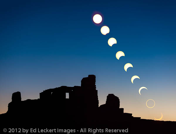
Composite photograph of the sun setting behind the Abo Ruins at the Salinas Pueblo Missions National Monument, New Mexico, during the annular solar eclipse of 2012.
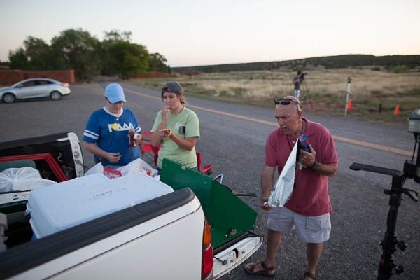
A group from Baylor University enjoys hot dogs while waiting for the eclipse, at the Abó ruins of the Salinas Pueblo Missions National Monument, New Mexico.
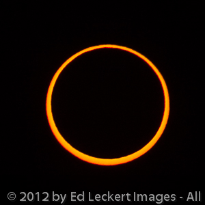
The sun at eclipse maximum during the annular solar eclipse of 2012


![]()
nice work Ed. you are now an official “expert” 🙂
Hey, the National Park Service said so! Who am I to argue? 🙂
Some day you’ll have to explain this “composite” image stuff to me. I think I can grasp it. Over beer. Nice shots, by the way! And for what it’s worth I totally buy the “Ed’s an expert” line!
Thanks, Dan! Any time you’re ready, let me know! I’ll give you a little head start now, though. You see the last image in this post, the one of just the sun at the eclipse maximum? It’s the same image that I used as the second to lowest image above with the Abó ruins in the foreground. Photoshop is used to combine, or composite, the foreground image with multiple images of the sun at various stages of the eclipse.