


No, I’m not trying to sell you a geotag. If I ever find one, maybe I will, but not now. Since I promised no sales pitches in this week’s post, here’s one in the “Adventures” category.
One of my faithful readers recently commented that she found it interesting that I could keep track of all the crazy (to us) Icelandic names of locations where my recent images were taken. Actually, that’s a very good point. I mean, keeping track of details on a shoot is hard enough anyway, but shooting in places with names like Ingjaldshólskirkja on the Snæfellsnes [ˈstn̥aiːfɛlsˌnɛːs] peninsula makes it even more difficult. Sure, some places have handy little signs that identify the location, and I can just photograph them for context. But sometimes I only have a rough idea from a road map about where I am or what the place is called. And if I do know exactly where I am and were to, say, take notes in a little spiral notebook, how would I sync up that information with the images later? And what if I’m hurrying to the next location to beat the sunset and don’t have time to take notes?
Well, it turns out there’s an easier way to keep track of my images, and it’s called “geotagging”.
Geotagging is “the process of adding geographical identification metadata to various media such as a geotagged photograph…”, according to Wikipedia®. Essentially, that means dropping the longitude and latitude on each image I take. If I do that to the majority of my images, and I do, that makes identification and captioning of the image that much easier, Additionally, I can always return to the precise location where the image was taken, if necessary.
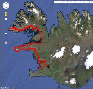
Map of Iceland showing my route to the Snæfellsnes peninsula and the Westfjords during my 2013 visit.
So, how do I do that? Well, as you probably already suspect, using GPS technology is the easiest way. While some cameras have built-in GPS capabilities, none of mine do, but that’s fine. GPS receivers can put a significant drain on battery life, so I’m not sure I’d want one dragging down my camera battery anyway. No, I actually use a separate GPS receiver that has the capability to track where I’ve been (and when). This is known as recording a “trip trace”. Every 30 seconds it logs my longitude, latitude, and altitude, as well as the exact time. To the right is a plot of a trip trace showing my travels throughout western Iceland, at least during those times when my GPS receiver was turned on.
So then whenever I capture an image using any of my cameras, the camera also records the approximate time in the image’s metadata. While it’s not as accurate as the time in my GPS receiver because it is set manually, I try to set the date and time in my cameras as carefully as possible.

DeLorme Earthmate PN-60
After I return home, I use software on my desktop computer to synchronize the timestamps on my images with those in my trip trace from the GPS receiver. Then the geographic coordinates (or an interpolation between two points) with the closest time is applied to the metadata of each image, and now I know exactly where they were all taken!
By using a separate GPS unit that has road as well as topographical maps pre-loaded (as opposed to a smart phone which requires a data signal to load maps), I also have a device that can be used for navigation and safety in remote areas. Bonus!
OK, so I have this geographical metadata in each image. What’s metadata, and how do I use it? Well, metadata is loosely defined as data about data. In this case, the real data is the image and the metadata consists of additional information such as the time it was taken, the camera settings I used, and the geographical coordinates and caption after I add those details when I get home.
It so happens that the tool I use to organize and post-process my images is very good at managing and displaying geotagging information. Adobe Photoshop Lightroom 5 contains a Map Module that can show me exactly where each image was taken on Google Maps. While working on almost any image in my library, all I have to do is click on the coordinates display beside the image and a map will display its location on a map. How cool is that?
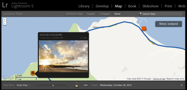
Lightroom 5 has the ability to display any geotagged image on a map.
The ability to return to a location has proven useful in the past as I described in my post “No Tilling Whom You’re Going to Meet” from back in June. You may recall that I needed to find the owner of a barn that I photographed back in 2008 in order to obtain permission from the owner to sell licenses of the image on the stock photography site gettyimages.com. The barn is no longer visible from the road, even if I had been able to remember which road I was on, which I did not. Using the metadata from the image, I was able to return to the site of the barn and luckily, find the owner at the same location and obtain a property release.
But what about visitors to my website? Can you see where my images were taken? Absolutely! While I don’t have this feature on my website yet, every image in my Image Gallery is also on the photo sharing site Flickr. Under each image thumbnail is a little icon that is a link to that image on Flickr. Click that.
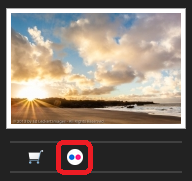
Below each image in my Image Gallery is a link to the image on Flickr.
Once on Flickr, scroll down and look under the image below “Taken on [date]”. The location listed there is actually a link that will take you to a map showing the image’s location.
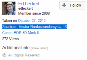
Below each image on Flickr is additional information, including the name of the image location.
So now you know how to follow me on my adventures around the world!


![]()
Very interesting, Ed!